|
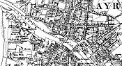
Ayr
is a Royal burgh, and the capital of the parish and shire of its name, 77 miles,
wsw of Edinburgh, 33 ssw of Glasgow, 34 ssw of Paisley, 12 ssw of Kilmarnock,
and 11 s of Irvine, situate in the north west angle of the parish where the
river Ayr flows past it into the Firth of Clyde. This border of Scotland has
been inhabited from the earliest period of authentic history; for when, in the
reign of Severus, the Roman fleet made the complete seaboard survey of Magna
Britannica, this part of the coast was crowded with a population that evinced no
amicable disposition towards the foreign obtruder; subsequently, however, the
persevering and insidious encroacher penetrated through southern Caladonia, and
the Celtic harp was hushed by the fanning wings of the Roman eagle; accordingly
we find that the site of modern Ayr retained, in the 11th century, the undoubted
traces of a Roman station; and tradition informs us that a hamlet, the vestige
of this station, was in existance until the latter part of the 12th century,
when William, surnamed the Lion, erased the odious blot, and laid the foundation
of a new town in the ashes of the former conquerer.
From the
Ayrshire Directory - 1837 - by Pigot & Co |